Nolo becomes Typhoon Nolo after crossing Pacific dateline
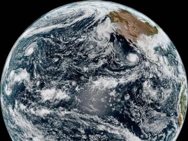
Nolo has changed from a hurricane to a typhoon after crossing the international dateline, while retaining maximum sustained winds of 115mph, the US National Hurricane Center said. The storm was moving west over open water and was not expected to threaten land through Friday, forecasters said.
Nolo has been renamed Typhoon Nolo after crossing the international dateline in the Pacific Ocean, although the powerful storm remained roughly as strong, the US National Hurricane Center said. In its final advisory on Nolo as a hurricane, the Miami-based centre said the storm had maximum sustained winds of 115mph (185kph). It was located about 395 miles (640km) west-southwest of Lisianski Island and moving west at 17mph (28kph).
John Cangialosi, a senior hurricane specialist at the centre, said the storm was over a large area of ocean and was not close to land. Forecasters expected it to continue moving west across the Pacific, with no land threat forecast through Friday. Tropical cyclones with winds above 74mph (119kph) receive different names depending on where they occur.
The terms hurricane and typhoon are used in different parts of the Pacific, while the South Pacific and Indian Ocean generally use the term tropical cyclone. Nolo strengthened rapidly on Saturday, reaching Category 3 hurricane status. It had earlier skirted Hawaii as a hurricane, weakened into a tropical storm and then regained hurricane strength on Friday.
Elsewhere in the Pacific, Hurricane Rachel was continuing westward away from Mexico. The hurricane centre said the storm was generating dangerous waves and swells along the coast of west-central Mexico and the Baja California Peninsula as it moved farther out to sea.
This independently written report is based on information supplied by the named publisher. Vertrix News has not independently verified the source report.